Final Report available: Hana Community Pathway Study
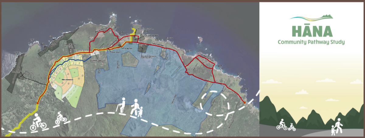
The Hāna Community Pathway Study envisions a 5.5-mile multimodal greenway linking important resources and services like Hāna Elementary and High School, Hāna Health, and the farmers' market, allowing both residents and visitors to safely walk, bike, or roll through their community. Currently, Hāna Highway is the only road connecting the daily services and destinations of its residents and visitors. This two-lane road is winding, narrow, and the speeds of cars on the highway frequently surpass the 25-mph limit.
The pathway aims to increase connectivity, accessibility, and safety by designating dedicated walkways and trails for pedestrians separate from the highway. A final meeting was held on June 23 at Helene Hall by Hana Bay. Find the final plan below.
Introduction
The Hāna Community Pathway Study is an effort to envision a multimodal, shared-use path connecting Hāna High and Elementary School, Hāna Health, the farmer’s market, and other community resources.
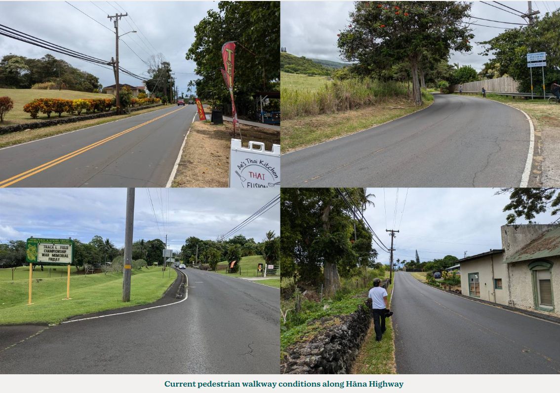
This pathway aims to enhance the travel experience for local pedestrians and bikers in Hāna, and to allow residents to safely connect with health services, schools, and other community resources throughout Hāna town. Currently, Hāna Highway is the only road connecting services and destinations frequented by Hāna residents and visitors on a daily basis. This two-lane road is winding and narrow, and cars frequently surpass the 25-mph speed limit. Some areas, like the stretch from Hāna School to Hāna Health, have only a narrow sidewalk directly adjacent to the highway. Other areas have no sidewalk at all, forcing pedestrians to walk in close proximity to passing cars. The community pathway aims to increase connectivity, accessibility, and safety by designating dedicated walkways for pedestrians and bikers that are separated from the highway.
The Hāna Community Pathway was originally envisioned several years ago, when Hāna Ranch made a generous offer to donate easements for a walkway along Hāna Highway. Hāna Ranch, Hāna Business Council, the Maui Metropolitan Planning Organization (Maui MPO), and others have worked together to secure $100,000 to conduct a study for the Hāna Community Pathway. The study will ensure these easements are used to increase connectivity, accessibility, and safety by evaluating potential pathway routes. The project team has gathered and synthesized public input to produce a plan for the community pathway, which will allow Maui MPO to take the next step of securing funding for the design and construction of the pathway.
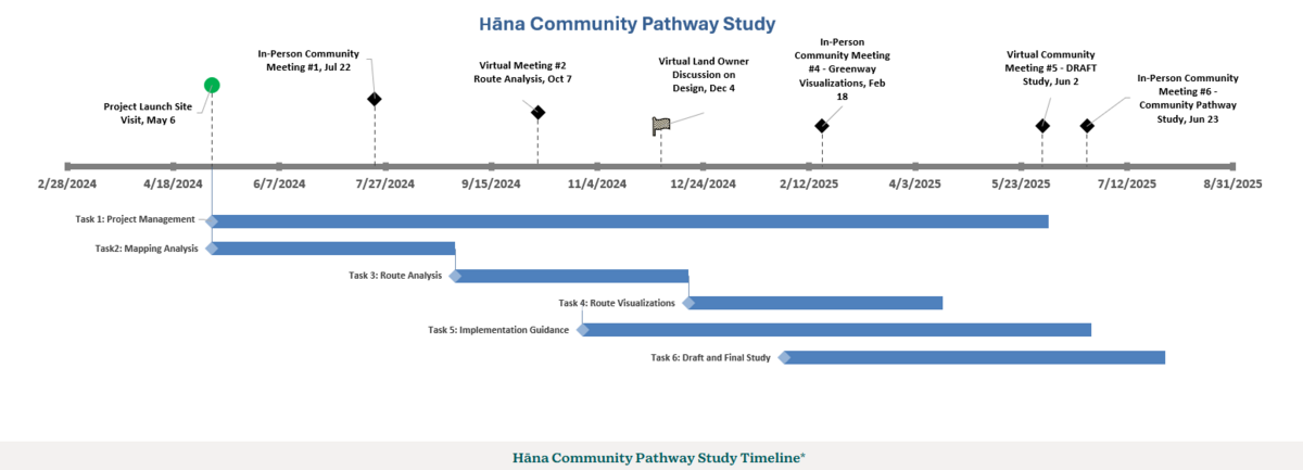
Study Timeline
Community engagement is crucial to the design process.
Five online or in-person community meetings have been conducted to hear community desires for the pathway, solicit feedback on proposed routes and design ideas, and create a plan that is compatible with the character of Hāna. Below is a timeline detailing the work and scope of the Hāna Community Pathway Study, which is broken down into separate tasks.
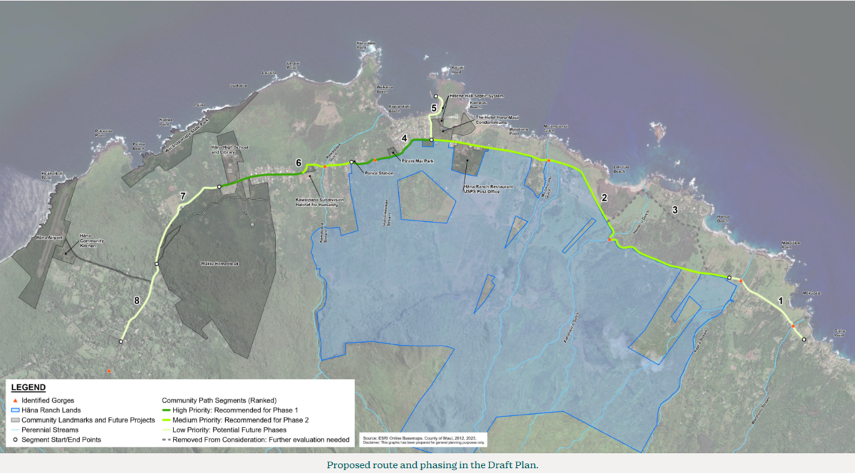
Proposed Route and Phasing
The proposed route and phasing included in the Draft Plan is shown below.
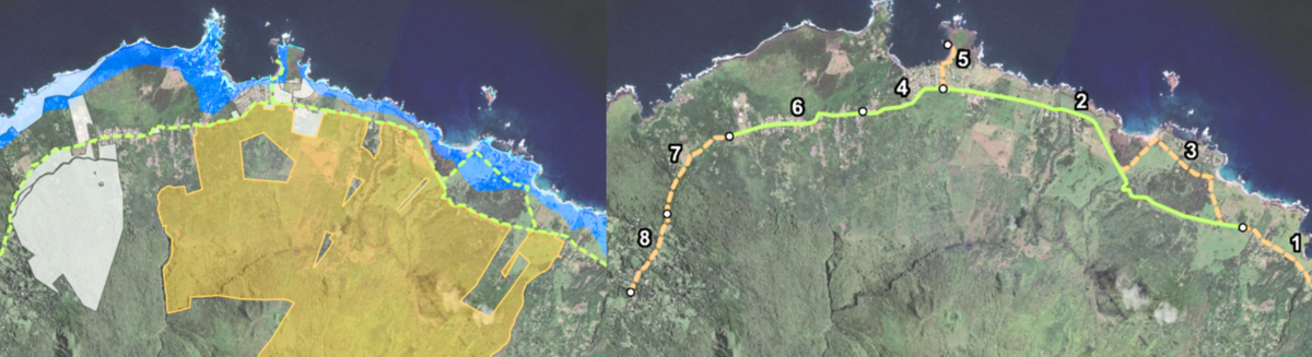
Mapping Analysis
Mapping analysis of the project area was used to inform the route alignment and design of the pathway. Publicly available geographic information systems (GIS) data and community feedback was used to identify pertinent geographic features, important locations, natural and cultural resources, and land ownership information. The map included information on:
-
Area of Study: The route study corridor under consideration for the community path. Roads and TMK parcels are shown for context. The route study corridor runs largely along Hāna Highway, extending from just southwest of Hāna Airport to Makaʻalae.
-
Community Assets: Community assets in Hāna were identified through research, site visits, and input from community members. These assets include important locations, natural and cultural resources, and roadway features such as gulches.
-
Sea Level Rise and Tsunami Hazards: Sea level rise (SLR) and tsunami hazards are an important pathway route alignment and design consideration. A 3.2 foot SLR scenario and the Extreme Tsunami Evacuation Zone are shown on the map. Portions of the route study corridor along Keawa Place and Haneoʻo would be impacted by these hazards.
-
Special Management Area: The purpose of the Special Management Area (SMA) is to regulate development in Hawaiʻi's coastal zones. The SMA is shaded in orange in the map. In general, areas makai of Hāna Highway are within the SMA. Some areas of the route study corridor between Keawa Place and Haneoʻo are also within the SMA.
-
HDOT (State) Jurisdiction: Some portions of Hāna Highway are under the jurisdiction of HDOT, and are shaded in red in the map. This has implications for permitting, construction, and maintenance of the pathway. Cooperation between state, county, and local stakeholders is necessary. Keawa Place and everything north of it is under HDOT's jurisdiction.
-
Route Segmentation and Feasibility Analysis: Based on the mapping analysis, initial stakeholder input, and information gathered at the first community meeting, the project team divided the study corridor into pathway segments reflecting the design opportunities and constraints along each part of the route. Each segment was then ranked based on five goals: (1) promoting safety; (2) natural & cultural assets; (3) design considerations; (4) strengthening connectivity; and (5) ease of implementation. A detailed description of these goals and the ranking methodology can be found in the draft plan .
-
Refining the Route Extent and Ranking Priority Segments: Feedback from all community meetings, comments, and stakeholder conversations to date were used to refine the route extent. The project team developed a phasing plan that identifies the highest priority segments for implementation based on feasibility and overall community support. Segments 4 and 6 near the school and town core were ranked the highest priority and recommended for the first phase of implementation. Other segments were ranked medium and low priority and recommended for future phases. Segment 3 running through Haneoʻo was removed from consideration and is not recommended for implementation.
Community Meeting Notes
You can view the notes from past meetings below.
COMMUNITY MEETING #1 NOTES: Route Alternatives Discussion
COMMUNITY MEETING #2 NOTES: Route Segments Analysis
COMMUNITY MEETING #3 NOTES: Pathway Visualizations
COMMUNITY MEETING #4: DRAFT Plan Virtual Public Meeting
COMMUNITY MEETING #5: FINAL Plan In-Person Meeting